The 6 hour Cyclic Navigator again proved to be an epic uni challenge. Storms in the 24 hours leading up the event combined with freezing wind and rain on the day turned trails into streams and made for super slippery testing conditions anywhere off the dirt roads.
My fitness is a long way down compared to this time last year due to recent injury and work requirements so the plan was to take it easy, enjoy the day and hopefully run the full six hours. I arrived at registration earlier than last year leaving more time to plan a route before the 10.00am start. Given the event is designed for MTB and how slow uni’s are in comparison it’s a tricky thing to guess a uni route over 6 hours. Excluding navigation errors, I work on the assumption I’ll cover about half the map within the 6 hours (whereas MTB will cover almost all of the map) and go from there, but it’s really only once you’re on the move that you get a good sense of your speed on the day.

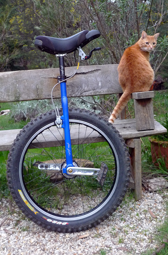
I’d never ridden in this section of forest, so the terrain was an unknown though the map made it clear a fair amount of climbing would be involved (+1600m for my route). I’d never ridden the geared 24″ unicycle off road for this long either. To minimize the load of spinning 1:1.5 on my legs and maximize the speed the plan was to use the easiest route, that was the theory anyway 🙂
The start was good fun, tagging onto the back of the slower MTB’s, enjoying high gear on on the GUni. In an event like this it isn’t long before riders scatter in all directions following their own route, so after reaching my first control point it was a few hours before I’d see any MTB riders again.

I had a fairly error free run in last year’s event, only going off course briefly once. This year I made two big mistakes in the first three hours that at times left me completely disorientated and wandering around in the bush looking for any sign of a trail. Firstly I missed a major turn, probably because I was enjoying scooting along downhill on the GUni too much, and didn’t realize the mistake until I reached the village of Barkstead – somewhere I shouldn’t have been until I looped back there ~3 hours later. I decided to rejoin my planned route and headed east across the map visiting a few control points on the way. It wasn’t long however before I turned off into the forest too early into a confusing network of unmarked firewood collection trails which soon disappeared and I spent a long time wandering around in the bush, finally coming out onto a dirt road, but which one I had no idea.
 of climbing, in and out of forest and plantations")
I sat for a while to clear my head and work out where I was with the help some munchies and energy gel. With 3 of the 6 hours already gone and having only reached a handful of control points the plan was to work out where I was, come up with 3 hour route back to the finish, and not get lost again. I’d already been to Barkstead so at least I knew where that was, so I headed west to Barkstead planning to loop south and then back east to the finish by 4.00pm. There were two controls worth a lot of points, so if nothing else I’d reach those.

I managed to stay on course for the second three hours reaching a bunch of controls, also coming across MTB riders on their way further south down the map. The MTB Orienteering guys hold their maps in a large snazzy rotating weatherproofed board on their handlebars which no doubt makes navigating easier and quicker. My map was stuffed in pocket, neatly at the start, scrunched up and shoved in towards the end! Very few things are named on the map, just enough to give clues. The map also doesn’t show the many unmarked trails, so you’ve really got to be paying attention.

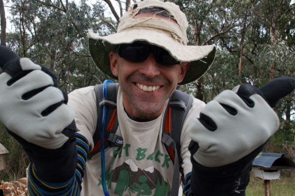
Heavy rain and cold gusty wind during the last couple of hours made for merciless conditions. The run back to the start/finish area was even tougher as you’re tiring, trying to visit as many controls as you can and still make it back before the 6 hour deadline. Unlike the MTB guys there’s no hammering speed to make up time and cover large distances super quick, though it was a lot of fun to scoot along on the GUni in high gear for extended periods and let it run more and more downhills… kind of funny when you’re fatigued, ‘don’t care if I crash just want to go fast‘ 😀
The KH24 GUni ran great the whole day. The Schlumpf hub was flawless in the wet muddy conditions. The XC GUni bar really added comfort and control. The dual layers of Merino wool worked great all day – keeping me warm and comfortable. I carried a rain shell along but never felt the need to put it on. I’m glad I waterproofed my Five Ten Karvers early in the week. It was only towards the end of the day that water started to seep through to my feet.

I arrived back at the Start/Finish with about 10 minutes to spare, completely and thoroughly exhausted. Not a bad guess time-wise in the end though I was super impressed to see the hardcore MTB Orienteering pro’s blast across the line with only 1-2 minutes of the event remaining, having reached almost every control point on the map.
A tough epic but super satisfying. Until next year then!